Region: East of England
Local Authority: North Norfolk
Owner Type: National Trust
Funding Body: Environment Agency
Year of Intervention: 2004 - 2005
Summary: Full recording of Blakeney Chapel Scheduled Ancient Monument and surrounding areas was achieved in advance of the site’s inevitable destruction by coastal change. The archaeological mitigation strategy, undertaken in response to a coastal realignment plan, represents a successful collaboration between English Heritage, Norfolk Landscape Archaeology, the National Trust, the consultants Halcrow, and the Environment Agency. Research has provided new evidence and interpretation of the site and the ground-plan of the building will remain visible to the public for its residual life.
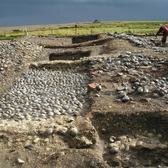
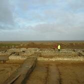
Description: The visible monument comprised fragmentary remains of flint cobble and brick walls, variously interpreted as a chapel, fort or barn, aligned east-west, with an ‘extension’ to the south. It was located on a low natural rise within undulating coastal pasture. Cartographic evidence indicated a structure at this site from at least 1586. There was no historical evidence for any religious dedication, but human remains were found to the north in 1924. There had been earlier investigations at the site by the Blakeney Area Historical Society, who maintained an active interest in the present programme of work.
Issue: Southwards migration of Blakeney Spit was periodically blocking the existing channel of the River Glaven to the north of the monument, resulting in flooding of the adjacent Blakeney Freshes Special Protection Area, and the village of Cley. The Environment Agency’s preferred option was to cut a new channel to the south. Once completed, this coastal realignment will leave the monument unprotected, so that it will first be overwhelmed by shingle spit migration and then destroyed by marine erosion.
Strategy: Following negotiations between stakeholders it was accepted that the only practicable mitigation was investigation by record. Norfolk Landscape Archaeology issued a Brief for archaeological assessment, following the guidelines set out in PPG16, and field evaluation was completed by the Norfolk Archaeological Unit in 2003. Results were sufficiently significant to justify full excavation and recording of selected areas, as well as topographic and palaeoecological investigations to place the site in context. This work was undertaken by Lindsey Archaeological Services and their consultants in 2004-5.
Outcome: Archaeological investigation indicated human activity in the area at most periods since the Neolithic, with some evidence for iron-working prior to the monument’s construction. An especially significant find was a rare 5th-6th century gold bracteate brooch. The main activity at the building itself was of 15th-16th century date, and now appears to have served a domestic rather than ecclesiastical function, as evidenced by internal partition walls and domestic debris. The structure might represent a warrener’s lodge. A full report on the work will be prepared for publication. The walls of the building were partly re-buried for H&S reasons, but the ground-plan of the structure was left clearly visible for public inspection so long as the monument survives.
Keywords: ASSESSMENT & CHARACTERISTION, SUSTAINABILITY
© English Heritage